CTS 8/18/07 – Lancaster County Central Park

DSC02334
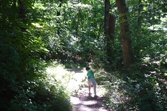
Took a short hike with my son on a stretch of the Conestoga Trail System that travels through Lancaster County Central Park. Round-tripped 4 miles (2 out and then back) from the East King Street entrance to Golf Road.

Friday night saw a severe thunder storm pass through the park and caused a significant amount of blow down damage to trees in the northeast section of the park, as seen in this photo. A few of the trees with blazes were knocked over completely.

Overall, a A pleasant stretch of trail with some nice views and a few moderately difficult hills. The park’s trail map seems pretty accurate. It turns out there are actually 10 hiking trails in the park, as described in the trail guide.


CTS Trail Map: Section A Complete – draft

I finally manged to get back out on the trail after a four month hiatus. Who knew that summer would be so hectic?

Last Friday was a blistering, humid day for a hike that was mostly on asphalt roadways bounded by tall corn, but I banged out 9 miles. That completed Section A for me and put a good start on Section B.

With a full section of the trail under my belt I turned to ArcMap and, with the help of the DS Mapbook extension, published my first-ever map book!

The 10 page map book  shows Section A at 1″ = 1/4 Mile scale. View or download it now!  Check it out and let me know what you think. As the title of this post indicates, this is my first attempt and I’ll be working to clean up the page layout and map elements in the near future.

CTS: A 6.66 – A 14.60 Images + Report

New Pics!
Erbs Covered Bridge Images from my third day on the trai, part of my project to update the trail maps for the Conestoga Trail System. It was a gorgeous day: mid 60s and cloudless blue skies. Winds in the 5 – 12 mph range. I got in about 8 miles and then had my wife and kids pick me up for the return trip to the truck. That sure is a better way to do things instead of backtracking. Click on the pic to the left for the Gallery.

Trail Report:
The trail seems to be in fair condition, but is soggy in a lot of places. That’s to be expected along a creek bed in early Spring–we have had a bunch of rain in the past 2 weeks. Look out for electric fences! In this stretch there are several of them that you have to cross under/over as you make your way through the fields. Also, cows and horses leave behind some big piles of stuff, so tread carefully. Continue reading

CTS North End Open Again

From: LancasterOnline.com: Community Websites – Lancaster Hiking Club

CONESTOGA TRAIL NORTH END REOPENS

With logging completed, we can again return to our usual route between Brubaker Valley Rd and Long Lane near the north end of the CTS. So welcome back hikers and trail care workers.

…and furthermore…

LOGGING ENDS.

WE ARE HIKING BY SPEEDWELL LAKE AGAIN BETWEEN LONG LANE AND BRUBAKER VALLEY ROAD NEAR THE NORTH END OF THE CONESTOGA TRAIL, LANCASTER COUNTY PA. HOORAY!

View CTS A0.00-A6.66 in Google Earth

I found an extension to ArcMap 9.2 today that allows you to export a feature class directly to Google Earth .kml file. It’s called ‘Export to KML Extension Version 2.3‘ and is published in the public domain by Kevin Martin of the Portland, OR GIS office. So, of course I had to test it out and post the results here. To make use of the trail map file you must first have installed Google Earth. Right-click on the link below and save the target to your hard drive and then double-click it to open the file in Google Earth.

Conestoga Trail System A0.00 – A 6.66

CTS Maps Updated

Gallery - Updated CTS Maps

I was just browsing the Lancaster Hiking Club site and found that the trail maps have been somewhat updated by the club. Three of the maps are still hand drawn but annotation has been done with a computer. Features like parking, camping, and mini marts are called out explicitly. Section B has been replaced entirely. It looks like some of the line work for the trail line has been cleaned up as well.

I better make contact with the folks soon….

CTS Trail Map: A 0.00 – A 6.66

I promised some work product from my project to update the trail map for Conestoga Trail System and here it is… 070413-cts_a_0-7.pdf.

If you have any feedback on the map, please leave it in the comments area below.

If you’re interested in getting this map in another format, or on a larger size sheet, please email me. I also have 2 foot contouring that can be overlaid on the map if needed.

CTS Images Miles 2.25 – 6.95

IMAGE_330.jpgI had a chance to get back on the trail today. It has been ten days since I started this project and the weather has been cold and dreary. Today I decided to hit the trail becasue I know I won’t make it out this weekend–snow in the forecast for Central PA!

It was mostly overcast and 45° F with a stiff wind when I started out around 3:00 pm. By the time I had to head home around 6:00 pm it was in the low 50’s with a much stronger breeze and clearing skies.

The images from this stretch include: two trail relocations, the Swiss Woods Bed & Breakfast, the Speedwell Forge Lake spillway, a mill race lock along Hammer Creek, alpacas, geese, Snavely’s Mill, and a cool mill house.

Strangest photo of note is probably a series of notebooks and folders I found abandoned along the Hammer Creek as I back tracked to my truck. If your name is Brett and you are wondering where your high school English folder and Alegbra text have gotten to, you can find them along the CTS!