Here’s the first official release of trail mapping for the J. E. Mack Scout Reservation in Newmanstown, PA.
It has been a long time coming. Other formats and versions will be posted soon.
Here’s the first official release of trail mapping for the J. E. Mack Scout Reservation in Newmanstown, PA.
It has been a long time coming. Other formats and versions will be posted soon.
I should have posted this new draft over the weekend but didn’t get a chance. Received some map corrections from Matt Meyers (of SAMBA) on Saturday and will incorparate changes in next week or so. Hoping to complete the trail information within the next 14 days and then publish 1.0 dta and mpas within 30 days.
Feedback is welcome…
This past weekend I had an excellent meeting with Matt Myers of SAMBA. We reviewed my trail mapping progress to date and did a significant amount of editing.
You can view the product of that meeting here. We’re still several steps away from a completed map but things are coming along quickly. Next steps include review of the map by the Ranger at Camp Mack and comign up with better symbology on the map to indicate single track vs vehicular trail etc.
I took time over my lunch hour today to trace the differences between Matt’s tracks and the trail ines I had already put on the map. At this point the maps shows all of the trail tracings and we need to pick which lines to keep, delete, and change.
I’ve marked on the map the areas that were significantly confusing in the track files that are going to require some extra clarification.
090227-updatedTrails.pdf (1.15 MB, Reader 9, georeferenced, layered)
This file is an 18×24 map at 1″ = 500′ to show allow you to zoom in on GPS point detail. Each black dot is a recorded point from a GPS track. The sections of trail that are updated are highlighted in orange.
I made a solid contact with Matt Myers of SAMBA today. We’re going to make our best effort to update the trail map. The division of labor will be pretty simple at first: I’ll provide whatever mapping savvy I can and Matt will provide local knowledge. We’ll be working with Gary at Camp Mack and Mike at Green Mountain Cyclery to keep everything in perspective. We’ll add more folks as needed.
After viewing my ‘Square One’ map Matt noted some trails no longer exist, others have been moved and some additions as well. He sent me a bunch of GPS track files he had previously recorded this evening. I converted them from GDB format to CSv with GPS Babel and then imported the CSV into ArcMap as an X/Y event theme and then exported that X/Y data to an ArcMap SHP file.
You can see from the PDF file below that once I overlaid all of the themes simultaneously there are some areas where I was reeally close and others that are significantly ‘not right’. and then there is one area that is just a mass of craziness.
My next step is to resolve the point themes into linework, I’ll leave that for this weekend.
If you’re going riding up at Mack this weekend in the wet and snow make sure to tke your GPS and ride a trail that hasn’t already been GPS’d.
090226-matts_tracks.pdf (960 KB)
SPECIAL NOTE: This PDF is layered and georeferenced. If you open it in Acrobat 9 you can turn on and off the different GPS tracks individually (use Layers menu at the left) and also can use the Analysis toolbar (under view menu) to find latitude and longitude coordinates.

Camp Mack Mapping Project – Square One (PDF @ 3.25MB)
Preliminary tracing of trails at Camp J.E. Mack Scout Reservation. I estimate tracing to be approximately 75% complete. Trail locations were marked based on interpretation of 2005 PAMAP aerial photograph (shown in background) and a 1995 hand drawn map by PG Kutz.
Hopefully this can serve as the basis of a new camp map for Pennsylvania Dutch Council Scouts and SAMBA riders alike.
DSC02334
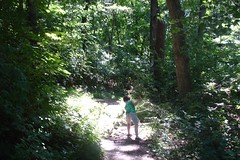
Took a short hike with my son on a stretch of the Conestoga Trail System that travels through Lancaster County Central Park. Round-tripped 4 miles (2 out and then back) from the East King Street entrance to Golf Road.
Friday night saw a severe thunder storm pass through the park and caused a significant amount of blow down damage to trees in the northeast section of the park, as seen in this photo. A few of the trees with blazes were knocked over completely.
Overall, a A pleasant stretch of trail with some nice views and a few moderately difficult hills. The park’s trail map seems pretty accurate. It turns out there are actually 10 hiking trails in the park, as described in the trail guide.
A.T. Essentials – Appalachian Trail Conservancy
In 1921, the Appalachian National Scenic Trail was simply an idea. Benton MacKaye – an off-and-on federal employee, educated as a forester and self-trained as a planner – proposed it as the connecting thread of “a project in regional planning.”
The efforts of countless volunteers made MacKaye’s idea a reality. Today, the Appalachian Trail is best known as a simple footpath, yet it also has other identities – as a greenway, a flyway, a “mega-transect”; by which to monitor environmental health. It is the mission of the Appalachian Trail Conservancy to ensure that future generations will enjoy clean air and water, scenic vistas, wildlife and opportunities for simple recreation and renewal along the entire Trail corridor.
The Real Mason Dixon Trail Website
The Mason Dixon Trail connects the Appalachian Trail with the Brandywine Trail. This 190-mile long trail starts at Whiskey Springs, on the Appalachian Trail, in Cumberland County, PA and heads east towards the Susquehanna River, passing through Pinchot State Park en route. The trail then follows the west bank of the Susquehanna south to Havre de Grace in Maryland. Across the river, the M-DT continues east, passes through Elk Neck State Forest, then on to Iron Hill Park in Delaware, north along the Christina River and White Clay Creek to the White Clay Creek Preserve. The trail then heads northeast to its eastern terminus at Chadds Ford, PA on the banks of the Brandywine River.
The Horse-Shoe Trail is a 140-mile hiking and equestrian trail that runs from Valley Forge to the Appalachian Trail in southeastern Pennsylvania.